Premise
The public conversation about historic preservation in Los Angeles operates without parcel-level data. Defenders argue that HCM status protects irreplaceable architecture; critics argue it blocks housing in transit-rich areas; both sides cite aggregate counts and rhetorical examples. This study tests the question with parcel-level fetchers and is honest about the limits — most HCMs produce signals too weak for the rubric to classify with confidence, and the audit names that as insufficient-data rather than dressing it up as a substantive verdict.
Six-axis rubric
Each parcel scores 0-10 on six axes. A: probability the structure would survive market forces without designation (low = needs protection). B: tourist and cultural currency (Wikipedia pageviews, walking-tour inclusion, NPR reviews). C: subsidy efficiency (Mills Act, federal HTC, contract value vs preservation outcome — currently null pending LA City per-property Mills Act data). D: externality load (code complaints, CSR cases, 311 encampment/dumping/graffiti, vacancy duration). E: neighborhood health (median household income, distress indicators). F: alternative-use value (parcel acres, TOC tier, TPA eligibility, zoning capacity).
Necessity classifier
After scoring, a downstream classifier reads the six axes plus typology and assigns one of: load-bearing (HCM doing real protective work — building would fall and no alternative tool fills the gap), blocking-redevelopment (HCM blocks higher-value use and is not protecting the structure), redundant (would survive without HCM— private value or alternative protection sufficient), failing-protection (HCM exists but vacancy and deterioration continue), insufficient-data (none of the above conditions match because the public signals are too weak to land anywhere — the residual bucket), exempt (religious, federal, or excluded category).
Findings
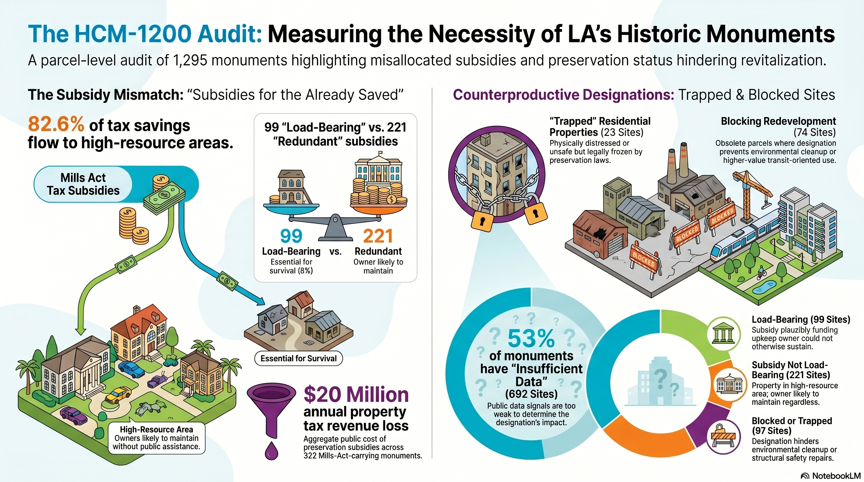
99 of 1295 HCMs (8%) classify as load-bearing — Mills Act contract on a property whose AECOM equity tier is medium-to-high or high barriers, signalling the subsidy is plausibly funding upkeep the owner could not otherwise sustain. 221 (17%) carry an active Mills Act contract but sit in the low or low-to-medium barriers tier — subsidy not load-bearing. 692 (53%) remain insufficient-data — no Mills Act, no demolition-pressure proxy, no other strong signal. 83 would survive without HCM status. 2 actively block higher-value use of vacant parcels. Across all 322 Mills-Act-carrying HCMs, ~$20 million in annual owner property-tax savings (~$2.18 million LA City revenue loss; the remainder is loss to LAUSD, the county, and other taxing entities). 82.6 percent of those savings flow to the low or low-to-medium barriers tiers — the 223 HCMs now flagged as subsidy-not-load-bearing.
What this is not
Not a delisting list. Not a model of what to demolish. The insufficient-data bucket is the rubric admitting it cannot see what the designation is doing on properties without a Mills Act contract — not a verdict that the designation is doing nothing. The load-bearing classification is the strongest claim the rubric makes; it says the city is paying for restoration on these properties and the program is the load-bearing element. Whether that subsidy is well-targeted is a separate question, addressed in the subsidies-for-the-already-saved policy critique.
What would still shrink the insufficient-data bucket
One signal remains missing: a demolition-pressure proxy — comparable non-HCM properties demolished within a defined radius and time window — would let the rubric detect load-bearing-via-procedural-friction cases (Cultural Heritage Commission saying no to a permit). Approximately 819 HCMs currently sit in insufficient-data with no Mills Act contract; some unknown fraction of those are presumably doing real protective work through the regulatory friction of the designation itself, but the rubric cannot tell which without the demolition-comparable data.
We do not have occupancy data — what "vacancy_status" actually measures
The field shown as "vacancy" or "vacancy_status" throughout this audit is a permit-activity proxy, not a measurement of occupancy. None of the underlying public open-data signals directly indicate whether a building is occupied. Of the 1295 active HCMs, the proxy values break down by the rule that fired:
- 548 "active" via recent investment over $250k in 60 months — substantial construction work on file, the strongest activity signal in the rubric
- 479 "active" via single permit within last 5 years — weak signal, one filed paperwork event
- 51 "partial" via single permit 5-10 years old — older paperwork
- 80 "unoccupiable" via typology non-occupiable — Hollywood Sign, tunnel portals, public art objects
- 2 "vacant" via no permits + high complaints or manual override
- 10 via manual override from the probe set
- 127 "unknown" via no signal — no permits, no complaints, no CSR cases on file
None of these prove occupancy. Construction investment proves someone is doing work. An institutional owner doing deferred maintenance, a developer pulling pre-demolition permits, or a vacant property being prepared for sale will all register as "active." Conversely, an occupied owner-occupied property that hasn't pulled a permit in 5 years will register as "unknown" or "partial." The audit treats this honestly now: each per-HCM detail page carries a "vacancy proxy basis" field naming the specific rule that produced the value, so readers can see exactly which signal fired.
What would give us real occupancy data: LADBS vacant building maintenance registration list (LAMC 91.8904.1), LADWP service status, USPS undeliverable-as-addressed rates, LA County Assessor property tax delinquency, owner-occupier homeowner exemption status, or aerial imagery + ML classification. None of those are currently integrated. This is the largest known structural limitation of the audit.
Three-tier workflow — GIS → HITL → site visit — 2026-05-12
The audit is not designed to autonomously declare which HCMs are type-1 (commercial obsolescence + contamination) or type-2 (residential structural damage trapped by HCM). Each tier of work produces a sharper conclusion at a higher cost. Tier 1 — GIS analysis: contextual signals from CalEnviroScreen, Mills Act appendix, LADBS permits, 311 CSR, code complaints. Automated, free, ranks ~1295 active HCMs into typed candidate lists. Tier 2 — HITL Street View verification: human reviewer opens the fresh Google Street View deep link per candidate, pans to find the building, confirms visible distress (boarded windows, tarped roof, fence collapse, abandoned signage). Manual, free, narrows candidates to confirmed-visible-issue cases. Described at /hcm-1200/candidates. Tier 3 — site visit by structural engineer or environmental scientist: ground-truth diagnosis, $1.5k-25k per property, gated by access pathway (city / Mills-Act / private + conservancy). Produces a Phase I environmental site assessment or structural condition report that is filable with the Cultural Heritage Commission. Described at /hcm-1200/site-visits, where the queue is maintained as a YAML file the user edits as candidates clear HITL review.
The orchestrator captured static Street View clips for every HCMduring the initial run, but those clips were aimed naively (heading defaulted to the street-facing facade direction, not adjusted for parcel geometry or building setback), so many miss the building entirely. The tier-2 deep-link approach gets around that by letting the reviewer aim the camera themselves rather than relying on our static captures.
GIS-derived contextual signals — 2026-05-12
Direct measurements of "is this parcel contaminated" or "does this residence have structural damage" are not in any public open-data feed. But those hidden variables correlate strongly with spatial context that is publicly fetchable. Three sources are now joined to every HCMby point-in-polygon or proximity match: (1) Cal OEHHA CalEnviroScreen 4.0 — cumulative pollution burden by census tract; (2) DTSC EnviroStor — 4,047 known cleanup sites in LA County, parcel-specific; (3) California Geological Survey liquefaction zones — 809 polygons designated under the Seismic Hazards Mapping Act of 1990 where liquefaction may occur during a strong earthquake. Each per-HCM detail page surfaces all three.
Distributions across the 1295 active HCMs: type-1 contamination probability (fused CalEnviroScreen + EnviroStor proximity) — 242 HCMs at ≥0.7, 458 at 0.4-0.7, 595 at <0.4. type-2 structural-risk probability (liquefaction zone membership + pre-modern-code designation date) — 111 HCMs at ≥0.6, 194 at 0.3-0.6, 990 at <0.3. 551 of 1295 HCMs have an EnviroStor cleanup site within 500m; 267 sit in CGS liquefaction zones. These are large baseline numbers — LA's preservation register is concentrated in the older, denser, more industrial-adjacent, more seismically-vulnerable parts of the city.
The two type-1 vacant cases score in the high range under the fused classifier: HCM-587 Lincoln Heights Jail at 0.73 (was 0.84 on CalEnviroScreen alone; the EnviroStor signal adds 4 cleanup sites within 500m — moderating tract context with parcel-specific evidence), HCM-790 Belmont Tunnel at 0.82 (5 EnviroStor sites within 500m — strong corroboration). HCM-587 also fires the type-2 structural risk signal at 0.60 (in a liquefaction zone, pre-1990 designation) — the Lincoln Heights Jail simultaneously has contamination overhang and seismic vulnerability, which is exactly the combination that makes the city's adaptive-reuse math hard.
Next GIS signals planned: CalGEM oil & gas wells (LA Basin has 4000+ wells, many in residential tracts), Alquist-Priolo fault rupture zones (sharper than liquefaction for direct fault-line risk), and Claude vision analysis of Street View + satellite imagery already pulled for each HCM(type-2 visible damage indicators — boarded windows, roof tarping, vegetation overgrowth).
Vision classification — 2026-05-12
Claude vision (sonnet-4-6) was run twice. First pass: 78 narrow candidates with formal distress signals — surfaced 1 abandoned (HCM-587 Lincoln Heights Jail, 5 indicators). Second pass: 342 broader field-reconnaissance candidates — older residential designations with no formal signal, where structural distress was suspected to hide in the long tail. Results: 15 distressed verdicts, plus 124 fair, 172 well_maintained, 31 cannot_determine. Total cost across both sweeps: $16.18.
The 15 distressed finds are the substantive result of the broader sweep: none of them appeared on the formal candidates page — they have no recent code complaints, no open CSR cases, no recent permit gaps that the original rubric was sensitive to. They are the type of distress the formal data channels miss. Examples: HCM-557 Wilbur F. Wood House shows fire_damage + structural_sagging + vegetation_overgrowth (only "fire_damage" verdict in the sweep). HCM-491 Charles B. Booth Residence shows tarped_roof + vegetation_overgrowth. Three neighborhood clusters of distress emerged (S Alvarado St × 2 adjacent, S Bonnie Brae St × 2, W 55th St × 2 adjacent) — adjacent residential HCMs with identical conditions suggest common-owner or block-level distress patterns worth investigating as groups rather than individually. See the field-reconnaissance findings section for the full list and cluster analysis.
Workflow validation — Burnside cluster — 2026-05-12
The tier-3 queue produced its first confirmed type-2 case the same day the rubric was built. HCM-423 / 424 / 425 (607, 626, 636 Burnside Ave apartment buildings, designated 1989) were ranked by the tier-1 GIS filter — 2 open CSR cases each, no recent permits, residential typology, designated >30 years ago. Tier-2 HITL Street View verification turned up neighboring 616 Burnside Ave apartments listed as "permanently closed" on Google Maps — a strong visible cluster signal that the entire block of HCM-protected apartments is non-operational. That is the textbook type-2 trapped pattern: building cannot operate (closed), cannot be demolished (HCM-protected), cannot be substantially altered (HPOZ / designation covenants). The three Burnside HCMs moved to the tier-3 site visit queue at high priority within hours of the candidate ranking surfacing them. Structural-engineer assessments at ~$2,500 per property paired across all three (~$7,500 total) would ground-truth the trapped hypothesis with code-defensible reports filable at CHC.
Two types of blocked / trapped HCM— now graded
Vacant or distressed historic-cultural monuments in LA fall into two qualitatively different categories. The rubric now classifies both — graded by confidence rather than collapsed under a single binary label.
Type 1: commercial / industrial / civic obsolescence + contamination overhang. Obsolete infrastructure (jail cells, rail tunnel portal, mid-century manufacturing) on parcels that may carry decades of soil contamination from prior uses. Alt-use is often real (transit-rich parcels, density-bonus eligible), but cleanup cost is part of the redevelopment math. 74 HCMs now classify in the type-1 family: 2 confirmed (vacant + high alt-use), 40 likely (partial vacancy + high alt-use, or high contamination probability + high alt-use on a non-residential parcel), 32 possible (moderate signals). The GIS-derived type-1 contamination probability now feeds the classifier directly; integrating DTSC EnviroStor + Cortese list would tighten the high-probability band further.
Type 2: private residences with structural damage, trapped by HCM-related laws. A fire-damaged 1920s Craftsman, an earthquake-damaged Victorian, a foundation-failed Depression-era bungalow — the building physically can't be lived in, but Cultural Heritage Commission demolition review + Mills Act / HPOZ alteration covenants prevent the owner from demolishing or substantially altering. Owner can't economically restore (cost exceeds value), can't sell because nobody wants to take on the trap, can't replace. 23 HCMs now classify in the type-2 family: 1 confirmed (residential + high structural-risk + covenant linkage), 16 likely (residential + high structural-risk), 6 possible. Integrating LADBS substandard / unsafe building registry (LAMC 91.8902) would convert the "likely" tier toward confirmed.
Both categories matter, and the policy responses differ. Type 1 wants targeted parcel-level adaptive reuse or carefully-scoped delisting paired with environmental cleanup. Type 2 wants either a structural-distress accelerated demolition pathway (with photo-documentation as the preservation outcome) or expanded restoration subsidy for owners genuinely trapped. Neither is "delist everything"; both deserve the graded handling the rubric now provides.
Classifier expansion — 2026-05-13
The prior classifier required a binary vacant + high-alt-use combination to register blocking-redevelopment, and required a manual signal to register trapped-residential. Only 2 of 1295 parcels tripped the blocking gate, and 0 tripped trapped. The GIS-derived type-1 contamination probability and type-2 structural-risk probability were already being computed by the upstream pipeline but ignored by the necessity classifier. Wiring those in plus adding graded "likely" and "possible" states moved the actionable count from 2 to 97. Insufficient-data dropped from 819 to 692. Each graded state has an explicit rationale describing which signals it required and which it did not — the rubric is now transparent about confidence rather than hiding the borderline cases in an unclassified bucket.
Vacancy inference fix — 2026-05-11
The vacancy inference rule was tightened after review showed that "no permit data in radius + 1 open CSR case" could describe active parcels that simply do not pull permits. The rule now requires corroborating signals (≥3 code complaints with old permits, ≥8 complaints without permits, or ≥3 open CSR cases). All 1295 HCMs have been rescored. 10 verdicts changed: 9 vacant→null plus 1 partial flip. The two remaining blocking-redev verdicts (HCM-587 Lincoln Heights Jail and HCM-790 Belmont Tunnel) survive on strong independent vacancy evidence.
Verdict-label fix — 2026-05-11
The residual bucket was originally labeled "symbolic" — implying the rubric had affirmatively determined the designation was functioning as recognition only. It had not. The bucket is what falls out when none of the other four conditions match (no subsidy, not vacant, not well-resourced, etc.) — which usually means the public signals are too weak to classify, not that the designation is provably ornamental. The label has been renamed insufficient-data to stop overclaiming.
Mills Act data integration — 2026-05-12
Melissa Jones at the LA Office of Historic Resources replied to the May 11 data request pointing to Appendix A of the 2022 program assessment, which contains 931 Mills Act contracts active in 2019 with per-property fields: address, APN, HCM number where applicable, MA contract number, 2019 enrolled value, trended value, owner savings, city unrealized revenue, equity index score, and equity index category. The appendix was extracted from the PDF via scripts/hcm-1200/extract_mills_act_pdf.py (pdfplumber-based) and indexed by HCM number and APN in scripts/hcm-1200/lib/fetchers/mills_act_appendix.mjs. All 1295 HCMs were rescored. The C-axis (subsidy efficiency) is now meaningful. Tax revenue figures came back per-property in the dataset itself; Jones suggested the LA County Assessor's office for the most current unrealized revenue numbers, which is a follow-up if the 2019 baseline drifts materially from 2025-26 reality. The CPRA fallback for May 18 is cancelled.
Load-bearing definition fix — 2026-05-12
The first pass at the Mills-Act-integrated rubric classified all 322 HCMs with a Mills Act contract as load-bearing — i.e. treated the existence of a contract as evidence the subsidy was doing real work. That was the same overclaiming pattern as the original "symbolic" label. A $69 annual savings on a $5 million Carthay Circle home is not load-bearing; the owner would have maintained the property regardless. The fix splits load-bearing by AECOM equity tier per the city's own equity analysis framework: contracts in medium-to-high or high barriers (where savings plausibly matter to the owner's ability to maintain the property) stay load-bearing; contracts in low or low-to-medium barriers move to subsidy-not-load-bearing. After the split: 99 load-bearing, 223 subsidy-not-load-bearing. 69 percent of what the first pass called load-bearing was actually a subsidy flowing to a property the owner would have maintained without it.
Sources
LA Hub ArcGIS historic-cultural monuments feature service (1295 active registry entries with polygons and designation dates), LA City open data permits (d9aa-v8bm), customer service requests (bsvt-chkv), 311 (h65r-yf5i), US Census ACS vintage acs2023_current, Wikipedia pageviews API, Anthropic Claude Sonnet for typology classification. Mills Act per-property contract list requested from LA Office of Historic Resources May 11 2026 — CPRA fallback queued for May 18 if no reply.