Premise
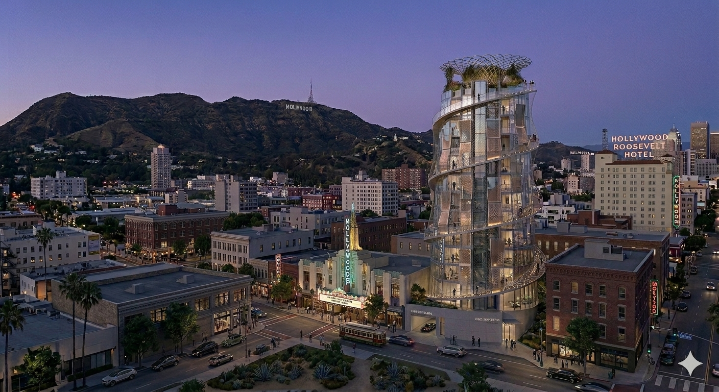
The occlusion needle treats density as a visual-impact problem rather than only a height problem. conventional massing fills the maximum footprint at lower height, obliterating neighborhood legibility and sky exposure. slender radial massing inverts that logic: a taller, thinner tower preserves the sky, historic view corridors, and streetscape continuity through minimal footprint and vertical optimization. the prototype combines a slim central core with radial occupied plates and a thick exterior facade system that reduces perceived mass from planned public viewpoints. it is intended as a replicable toolkit for historic districts that need housing without destroying the urban field they sit within.
Radial prototype components
The tower is decomposed into four functional systems. the central service core is the slim structural and utility spine — the tower's minimum essential footprint. radial floor plates branch outward from the core as tapered unit distribution, wider at the base and narrowing toward the peak. spiral exterior circulation wraps the outside as linear wraparound balconies that serve simultaneously as access, outlook, and civic sequence. the passive optical relay facade is the thick exterior periscope array that mitigates perceived mass — the system that makes the other three components disappear from key public viewpoints.
Optical relay facade
The facade is not a screen — it is a visual permeability engine built from three sequential components. intake mirrors capture sky, landscape, or streetscape fragments from the opposite side of the tower. prisms and relay plates channel that captured light through the facade thickness. output faces redirect it to the viewer-facing surface. the result is not universal invisibility but calibrated permeability: by mechanically relaying selected background vectors, portions of the tower read as reflected environment rather than solid obstruction. a flat curtain-wall grid fails this task entirely because flat panels cannot direct light toward targeted public viewpoints. panel angles tuned from spherical normals can, which is why the radial organization is not decorative — it is the optical targeting system.
Sphere-based form
Sphere-based geometry organizes the tower as a radial field. the exterior stair and balcony bands spiral around the core, while panel angles are tuned from spherical normals rather than flat curtain-wall logic. each optical cell points toward an exact source vector, relay path, and viewing zone — giving the facade the behavior of a periscope array rather than a decorative skin. radial organization means exterior stairs, balcony bands, and optical cells all share the same angular rule, which keeps the structure, the circulation, and the optics aligned without custom solutions at each level.
Vertical logic
The section divides into two named zones that serve different purposes. lower levels carry a wide base: a larger occupied ring, higher density of individual housing units, and maximum urban housing yield at grade. upper levels carry a narrow peak: the section tapers into fewer units with massive outward view exposure, minimizing the overall skyline footprint at the levels that are most visible from a distance. the taper is not aesthetic — it is the mechanism that lets the tower house significant density at the base while disappearing from the skyline at the top. residents in the upper units get the tower's best view exposure; the historic fabric below gets the smallest possible skyline interruption.
Spiral circulation as civic sequence
The exterior spiral rescues circulation from the hidden service core. residents have two ascent options: the high-speed central elevator core, or the exterior spiral walk. the spiral is not a fire stair — it is a civic sequence. landings intentionally expand into pause points and partial public overlooks rather than bare flat platforms. each landing becomes a personalized threshold into internal properties, turning vertical movement into a viewing sequence rather than a dark, internalized stairwell. this distinction matters because the spiral is visible from the street and from key viewpoints, so it must perform as civic architecture rather than building infrastructure.
Spiral safety envelope
The exterior spiral is protected by four named safety systems rather than heavy guard walls. fine-gauge stainless tension mesh replaces solid barriers, preserving visual permeability while preventing falls. calibrated openings and bird-safe fritting protect urban wildlife from dangerous glass collisions — a real performance requirement for a tower with significant glazed surface. continuous ergonomic handrails ensure absolute pedestrian stability during ascent at every step of the spiral. motion-activated amber path lighting illuminates landings and thresholds only when occupied, keeping night circulation safe without turning the spiral into a bright skyline nuisance. the four systems together let the envelope stay visually light while meeting every safety obligation.
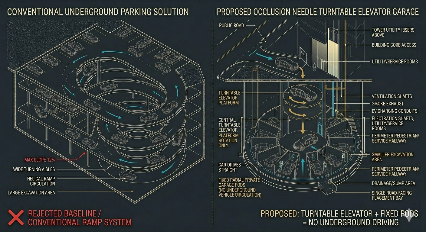
Excavation bottleneck
Conventional underground parking fails specifically in compact historic lots through three structural problems. turning radii require massive spatial waste for human vehicle maneuvering — the space a driver needs to turn a car around governs the entire floor plate. ramp lengths dictate deep, expensive excavations that threaten adjacent historic foundations — in a dense historic block, the ramp often has to go under neighboring buildings. structural spans require heavy, wide-spanning support systems to keep aisles clear, which adds cost and excavation depth. in compact historic lots, the space required for human drivers to maneuver often kills the project's financial and structural viability before it begins. the turntable system addresses all three by removing human maneuvering from the equation entirely.
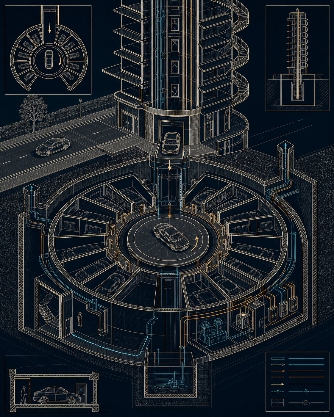
Turntable parking
Parking is handled as a compact radial pod system fed by a circular elevator platform. the 3-step operation eliminates all driver maneuvering. step 1: placement bay — the driver enters a single controlled entry throat at street level; no navigation required. step 2: turntable alignment — the central circular platform mechanically rotates to precisely align with the assigned radial pod angle. step 3: forward movement — the gate releases and the driver moves directly forward into their private pod; absolutely no reversing or maneuvering required. compared to a conventional ramp garage: movement type shifts from driver maneuvering to controlled mechanical alignment; spatial waste collapses from extensive driving aisles and ramps to a single central elevator throat; excavation volume goes from massive footprint and deep digging to minimal, highly consolidated radius; unit type shifts from a shared open driving field to private, assigned, enclosed pods; and adaptability opens up — the turntable can be fed by lateral drives under adjacent parcels, not just the immediate parcel footprint.
Garage pod access
Each vehicle bay operates as an assigned room, not a stall. the pod provides secure storage, EV charging, and maintenance space — a private enclosed room rather than an exposed slot in a shared driving field. a perimeter hallway gives each car owner a dedicated doorway to the rear of their pod for direct, safe pedestrian access without entering the central vehicle elevator throat. this separation is a safety-by-design principle: residents never have to walk through the vehicle throat to reach their cars. the parking level behaves as a ring of assigned private rooms around a shared mechanical turntable, not a garage people drive through.
Life safety matrix
By removing human maneuvering from the garage, the engineering equation changes entirely — from designing for maneuvering space to designing for redundancy and egress. four vectors replace the conventional safety checklist. ventilation routing: optimized air exchange isolated from pedestrian zones so exhaust does not enter the spiral or resident paths. fire access integration: dedicated suppression lines run directly into private pods rather than relying on access through the vehicle throat. pedestrian egress pathways: direct, stair-linked exits that completely bypass the vehicle throat so residents can evacuate without interacting with the mechanical system. mechanical failure recovery: manual override sequences and backup winch systems that allow retrieval even when the turntable is non-functional. retrieval as a queue — pod → platform → turntable aligns to exit → gate opens → return to grade — is also the egress sequence, which makes normal operation and emergency operation the same procedure.
HPOZ compatibility matrix
Compatibility in a historic preservation overlay zone is tested through six named categories rather than a single massing review. massing: verifying the preservation of historic skyline ratios at planned public viewpoints. street-level experience: testing pedestrian scale and civic integration — whether the needle reads as an insertion into the urban fabric or a rupture of it. glare and heat: ensuring the optical relay panels do not create hazardous reflections that affect neighboring buildings, pedestrians, or drivers. bird safety: auditing the barrier fritting and tension mesh systems against bird-collision standards for the specific facade exposure. night appearance: simulating the amber path lighting to confirm night circulation safety does not produce skyline light pollution. privacy: running public-viewpoint simulations to ensure relayed light does not expose internal residential spaces. each test can generate a design adjustment — massing triggers taper changes, glare triggers panel angle revisions, privacy triggers relay path recalibration.
Replicable toolkit
The synthesis: by treating density as a visual-impact problem and leveraging analog optics alongside mechanical excavation efficiency, the occlusion needle proves that high-capacity housing and historic neighborhood legibility are no longer mutually exclusive. the needle can appear as a field of insertions in a historic district — slender cyan anchors that preserve the street fabric, maintain optimized view corridors, and keep the low-rise integrity of the surrounding block intact. analog optics + excavation efficiency = urban preservation. the two systems work together: the optical relay facade reduces perceived mass from public viewpoints, and the turntable garage eliminates the excavation footprint that would otherwise threaten historic foundations. neither system alone is sufficient; combined, they make the needle deployable in contexts that would reject any conventional tower form.
Site study — three LA insertion candidates
The replicable toolkit premise is tested here against three real Los Angeles lots where conventional massing fails the historic-district test in a measurable way. each site is open or tear-down grade, in a Transit Priority Area with TOC Tier 2 or better entitlement, immediately adjacent to an HPOZ or registered historic district, and subject to a named public viewshed that conventional density would permanently sever. the three optical relay targets are distinct: a hillside foliage vector at Whitley Heights, a mountain backdrop relay in Highland Park, and a park treeline vector at Los Feliz. three relay types at three HPOZ adjacency conditions, calibrated to three different viewpoint geometries. sites are ranked by the severity of the conventional-massing failure — the degree to which any standard tower destroys the specific public view the designation was created to protect.
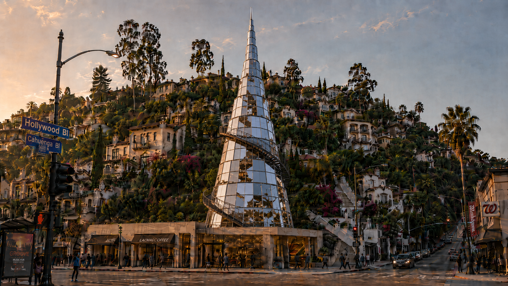
Site 1 — Cahuenga Throat, Whitley Heights / Hollywood
A 0.55-acre aggregate of surface parking and single-story commercial on the 1620–1720 block of Cahuenga Blvd between Hollywood Blvd and Selma Ave, at the base of the stair streets leading into Whitley Heights. the HPOZ boundary is 20 meters north. Whitley Heights (HPOZ established 1982) was LA's first residential historic preservation overlay zone — 420+ contributing properties in an Italian Renaissance Revival hillside composition whose primary public sightline is from Hollywood Blvd looking north-northeast, where the stair streets and roofline silhouette read as a single composed hillside village against the sky. TOC Tier 3 from the Hollywood/Vine Metro Red Line station (0.35 miles). the massing problem: a conventional 5-to-7 story block projects above the Whitley Heights ridgeline as seen from Hollywood Blvd, destroys the hillside silhouette, and casts afternoon shadow across the stair streets that are the HPOZ's primary pedestrian experience. the needle response: a two-zone vertical section. the occupied lower tower is 48–52 ft diameter at base, narrowing continuously to approximately 8–12 ft at the 88 ft Whitley Heights ridgeline datum — wide enough for habitable radial floor plates, tapered aggressively through the mid-section via a concave taper curve rather than a linear slope, with most visible width concentrated in the lower third. above the last occupied ring, an unoccupied optical mast extends an additional 20–24 ft, narrowing from roughly 8 ft to a 1–3 ft terminal point at approximately 108–112 ft total visual height. the occupied mass remains below the Whitley Heights ridgeline; only the terminal optical mast rises above it as a near-line element. optical relay targets the hillside foliage vector — intake panels on the upper north face capture rock garden, foliage, and sky from the hillside above and behind the lot; output faces on the south-facing panels relay that image toward pedestrian viewpoints on Hollywood Blvd. turntable garage entry on Selma Ave; no ramp excavation reaching the HPOZ foundation zone. civic move: the spiral walk descends to a public pavilion at grade that frames the Whitley Heights stair access as a neighborhood gateway.
Site 2 — York/Figueroa node, Highland Park
A 0.7-acre surface parking lot and single-story commercial aggregate at the northeast corner of York Blvd and Figueroa St, 300 feet from the Metro L Line Highland Park station. the Garvanza HPOZ boundary runs along the rear alley — approximately 700 contributing Craftsman bungalows within 0.5 miles. York Blvd's primary public sightlines terminate east and west in the San Gabriel Mountain backdrop; the station plaza looks north across the Garvanza hillside silhouette. both viewsheds make the York/Figueroa node the visual hinge between the transit infrastructure and the historic residential fabric — the inflection point where density lands first and where the massing argument is settled. TOC Tier 3–4 from the Highland Park station. the massing problem: a conventional 5-story box at York/Figueroa terminates the mountain sightline at the most visible intersection on the corridor, projects above the Garvanza hill silhouette from the station plaza, and casts afternoon shadow across the highest-foot-traffic sidewalk segment entering the historic commercial strip. the needle response: 112 ft tip calibrated to the Garvanza ridgeline from the station plaza, finishing against sky. the east face of the lot has a direct mountain vector — intake panels on the back of the tower capture the San Gabriel backdrop, relay through the core, output on the west (York Blvd viewer-facing) face. from York Blvd looking east the mountain sightline passes through the building rather than ending at a flat facade. the ground-floor base plate on the York Blvd face uses brick and timber matching the HPOZ commercial row; the needle only begins its visual identity above the existing commercial eave height. turntable garage entry on Figueroa St; no ramp excavation reaching the York Blvd masonry frontage foundations. civic move: the station side of the base plate is held open as a covered arcade between the Metro exit and the York Blvd commercial strip, solving the pedestrian connectivity gap the node has lacked since opening day.
Site 3 — Vermont/Los Feliz Gateway, Los Feliz
A 1.0-acre commercial strip — fast food drive-through, single-story auto dealer service, surface parking — at 1810–1900 N Vermont Ave, the first major intersection north of the Vermont/Sunset Metro station (0.45 miles south, TOC Tier 2–3). Los Feliz Estates Historic District (California Register 2018) begins half a block north — approximately 600 contributing pre-1940 residences in a large-lot early-20th-century neighborhood whose California Register nomination specifically identifies the Los Feliz Blvd Griffith Park approach vistas as a character-defining feature of the district. the Griffith Park hillside is the dominant visual backdrop from the Vermont/Los Feliz intersection looking northeast. the massing problem: a conventional 6-story block creates a scale rupture at the historic district entry, obstructs the Griffith Park hillside view from Vermont Ave looking northeast, and perpetuates the drive-through curb cut that fragments the pedestrian corridor between the Metro station and the park. the needle response: 138 ft tip calibrated to finish above the first Griffith Park treeline ridge as seen from Vermont/Los Feliz — the tip reads against sky, not in front of the park hillside. optical relay targets the park treeline and sky; the east-northeast face captures the canopy vector, relays it to the southwest (Vermont Ave) face, making the 60-to-110-foot band of the tower read as permeable to the park behind it at the levels where silhouette conflict would otherwise be most acute. the base plate at Los Feliz Blvd is held to minimum width with maximum north setback, preserving the landmark median tree sightline gap at grade. turntable garage entry on the rear alley; the drive-through curb cut is eliminated entirely, restoring the full Vermont Ave sidewalk width with continuous planting strip. civic move: a public Griffith Park overlook terrace at the spiral midpoint (approximately 40 feet) is accessible from Vermont Ave via the open spiral walk, translating the California Register nomination's language about Griffith Park visual access into a public program the building delivers as base infrastructure.